
DATABASE FOR SOCIO-ECONOMIC ANALYSIS
General Database
Giovanni NASA

Giovanni is a NASA Goddard Earth Science Data and Information Services Center (GES DISC) Distributed Active Archive Center (DISC) web application that provides a simple, intuitive way to visualize, analyze, and access Earth science remote sensing data, particularly from satellites, without having to download the data.
Socioeconomic Data and Applications Center (SEDAC)

Focusing on human interactions in the environment, SEDAC has as its mission to develop and operate applications that support the integration of socioeconomic and earth science data and to serve as an “Information Gateway” between earth sciences and social sciences.
United States Geographical Surveys (USGS)

Created by an act of the United States Congress in 1879, the USGS provides science for a changing world, which reflects and responds to society’s continuously evolving needs. As the science arm of the Department of the Interior in the United States if America, the USGS brings an array of earth, water, biological, and mapping data and expertise to bear in support of decision-making on environmental, resource, and public safety issues.
Copernicus Data Space

The Copernicus Data Space Ecosystem supports users in accessing, viewing, using, downloading, and analyzing data. The Copernicus Data Space Ecosystem is set up to further improve access and exploitation of the EU’s Copernicus satellites data. The service aims to support users in building various applications needed to provide accurate, timely and objective information which are crucial to create a more sustainable future.
Global Forest Watch
Global Forest Watch (GFW) is an online platform that provides data and tools for monitoring forests. By harnessing cutting-edge technology, GFW allows anyone to access near real-time information about where and how forests are changing around the world.
Open Data Cube
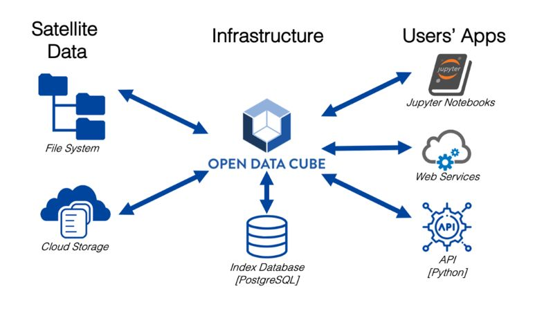
The Open Data Cube (ODC) is a open source project that was motivated by the need to better manage Satellite Data. This was born out of the work done under the “Unlocking the Landsat Archive” and the Australian Geoscience Data Cube (AGDC) projects. The ODC has evolved to support interactive data science and scientific computing. ODC will always be 100% open source software, free for all to use and released under the liberal terms of the Apache 2.0 license.
Google Earth Engine

Google Earth Engine is a computing platform that allows users to run geospatial analysis on Google’s infrastructure.
LATTICE [Grid-Cell Data]
Gridded Population of The World version 4 (GPWv4)

Source
Center for International Earth Science Information Network (CIESIN, Columbia University)
Data Availability
Population Count, Population Density, UN WPP-Adjusted Population Count, UN WPP-Adjusted Population Density, Data Quality Indicators, Land and Water Area, Administrative Unit Center Points with Population Estimates, National Identifier Grid, Basic Demographic Characteristics; etc
Method
Extrapolating the raw census and proportionally allocated to the cell by using a uniform area weight
MetaData/Documentation
2018 : Click here
LandScan
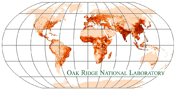
Source
Oak Ridge National Laboratory
Data Availability
Global Population Distribution Data
Method
The LandScan Global Population Project is a worldwide population database at 30 x 30 (arc second) resolution for estimating ambient populations at risk.
LandScan itself uses available data and satellite imagery to map geographic areas and superimpose layers of information at a roughly 1 km spatial resolution. Then, the best available census counts are distributed to cells based on probability coefficients which, in turn, are based on road proximity, slope, land cover, and nighttime lights and are exported as Binary format.
Furthermore, verification and validation (V&V) studies have been conducted routinely for all regions and more extensively for portions of the Middle East and the Southwestern United States. In addition, global coverage has been completed for the datasets and the datasets have been actively and successfully licensed with updates released annually.
MetaData/Documentation